
Burlington is a Unique Community
The City of Burlington is a major infrastructure corridor (QEW, Hwy 407, CN, CP and GO transportation, Hydro and Enbridge Gas Pipeline). Wedged between the top of the Niagara Escarpment and Lake Ontario, significant stormwater drainage passes through the City in its 17 creeks. A significant drop in elevation of over 250m in only 12km. The City is currently has fixed boundaries for development. There is no possibility of creating new Major Parks/Open Space that could replace the Millcroft Golf Course. If it is developed as proposed, the greenspace is gone forever.

The Millcroft neighbourhood is bordered by the Alton and Orchard neighbourhoods to the north and east. These communities are defined by smaller lot sizes and limited boulevard space that substantially limit tree canopy in the surrounding areas. The 2020 Official Plan proposes the new Uptown neighbourhood to the South, which will provide up to 4,000 households in a high-density format. Our community is bordered by the major transportation corridors of Dundas Street (Highway 5), Appleby Line and the CN Rail line. Appleby Line connects Highway 407, QEW (through interchanges) and the Appleby Go station.
Hardening of the Millcroft Golf Course surface through housing development may impact not only the Millcroft community but areas closer to the lake as climate change unleashes higher volumes of precipitation during more violent weather patterns.
The 2014 flood that this City endured is fresh in our memories and may serve as an early warning. This exceeded hurricane Hazel levels, otherwise categorized as the “One Hundred Year Flood”.
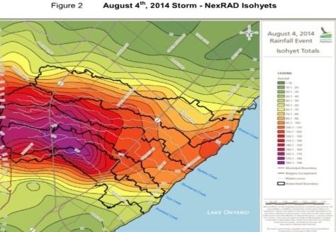
The results of Conservation Halton’s precipitation analysis after the 2014 Burlington flood shows heavy concentration, predominantly over Millcroft, and the burden on the creeks draining to Lake Ontario.